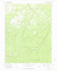
1973 Map of Pryor Creek
USGS Topo · Published 1975About this map
The Uncompahgre National Forest dominates this high-country landscape along the border of Ouray and Montrose counties. In the early 1970s, this area served as a critical node for forest management and seasonal mountain activity, centered around the Silesca Guard Sta and the nearby settlement of Silesca. The map reveals a complex network of high-altitude water sources, including Silesca Pond and the headwaters of Pryor Creek, feeding into larger systems like Clear Creek and Spring Creek.
Find a feature on this map
25 named features on this map. Tap any name to fly to it.
Don’t see what you’re looking for? This feature index may not catch every label — zoom into the map to look around manually.
Map Details
Editions of this 1973 Pryor Creek Map
3 editions found
Other maps of this area

1909 · Montrose
USGS Topo · 1:125,000

1911 · Montrose
USGS Topo · 1:125,000

1956 · Montrose
USGS Topo · 1:250,000

1956 · Moab
USGS Topo · 1:250,000

1959 · Moab
USGS Topo · 1:250,000

1959 · Montrose
USGS Topo · 1:250,000

1960 · Montrose
USGS Topo · 1:250,000

1960 · Moab
USGS Topo · 1:250,000

1962 · Moab
USGS Topo · 1:250,000
1962 · Montrose West
USGS Topo · 1:24,000