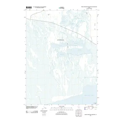
2011 Map of Public Shooting Grounds
USGS Topo · Published 2011About this map
Public Shooting Grounds Waterfowl Management Area dominates this landscape along the northeastern fringes of the Great Salt Lake. This marshy environment is defined by a complex network of wetlands and shallow basins, including Pintail Lake, Widgeon Lake, and Crocker Lake, which were historically managed for migratory bird populations. In the northern reaches, Connor Springs feeds into the Conner Basin, while the terrain rises toward Painted Rock and the edge of Little Mountain. A unique geological landmark, Fish Fossil Rocks, is noted near the southern shoreline, suggesting the deep prehistoric history of the ancient lakebed. The map illustrates the specialized infrastructure of the management area, including the distinctive route of Mollys Stocking and the straight-line division of 10000 W Rd cutting through the basin floor.
Find a feature on this map
19 named features on this map. Tap any name to fly to it.
Don’t see what you’re looking for? This feature index may not catch every label — zoom into the map to look around manually.
Map Details
Editions of this 2011 Public Shooting Grounds Map
This is the sole edition of this map. No revisions or reprints were ever made.
Other maps of this area

1954 · Whistler Canal
USGS Topo · 1:24,000

1954 · Public Shooting Grounds
USGS Topo · 1:24,000

1954 · Brigham City
USGS Topo · 1:250,000

1955 · Mouth of Bear River
USGS Topo · 1:24,000

1955 · Bear River City
USGS Topo · 1:24,000

1958 · Brigham City
USGS Topo · 1:250,000

1961 · Thatcher Mountain
USGS Topo · 1:62,500

1961 · Tremonton
USGS Topo · 1:24,000

1962 · Brigham City
USGS Topo · 1:250,000

1966 · Thatcher Mountain SW
USGS Topo · 1:24,000