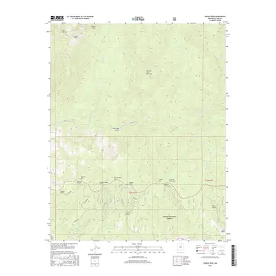
2017 Map of Pueblo Peak
USGS Topo · Published 2017About this map
The high alpine environment of the Sangre de Cristo Mountains dominates this portion of Taos County, centered on the prominent summit of Pueblo Peak. This landscape is defined by its deep drainages and sharp ridgelines within the Carson National Forest, where the complex hydrology of the Rio Pueblo de Taos and Pueblo Canyon carves through the terrain. The map illustrates a high-altitude wilderness characterized by significant peaks such as Palo Encebado Peak, Capulin Peak, and Casita de Piedra Peak. Numerous canyons, including Frijoles Canyon and Ranchos Canyon, intersect the slopes, highlighting a rugged drainage network that includes Capulin Spring. The absence of developed roads or settlements reflects the protected and primitive nature of this mountain territory, serving as a detailed record of the natural landforms and forest boundaries in the early twenty-first century.
Find a feature on this map
25 named features on this map. Tap any name to fly to it.
Don’t see what you’re looking for? This feature index may not catch every label — zoom into the map to look around manually.
Map Details
Editions of this 2017 Pueblo Peak Map
This is the sole edition of this map. No revisions or reprints were ever made.
Other maps of this area

1954 · Raton
USGS Topo · 1:250,000

1958 · Raton
USGS Topo · 1:250,000

1963 · Wheeler Peak
USGS Topo · 1:24,000

1963 · Eagle Nest
USGS Topo · 1:24,000

1963 · Arroyo Seco
USGS Topo · 1:24,000

1964 · Taos
USGS Topo · 1:24,000

1964 · Ranchos De Taos
USGS Topo · 1:24,000

1965 · Osha Mountain
USGS Topo · 1:24,000

1965 · Palo Flechado Pass
USGS Topo · 1:24,000

1965 · Pueblo Peak
USGS Topo · 1:24,000