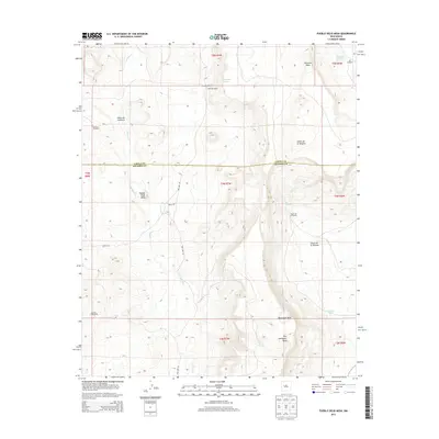
2013 Map of Pueblo Viejo Mesa
USGS Topo · Published 2013About this map
Pueblo Viejo Mesa dominates this high-desert landscape on the border of Cibola and Socorro counties, where the high-altitude topography of New Mexico's rangelands is marked by significant mesa formations and deep drainage systems. The survey illustrates a terrain defined by water scarcity and cattle ranching, with critical water sources like Victorino Spring and Laguna Del Oro providing rare relief in an arid environment. Long-established ranching operations, including Victorino Ranch, Red Lake Ranch, and Field Ranch, anchor the human presence here. These homesteads are connected by primitive routes such as Red Lake Rd and Merch Rd, while features like the Oro Windmill and Number 7 Windmill signal the necessary infrastructure for surviving on this plateau. To the east, the terrain drops into Cañon de la Ternera, a major canyon system carved through the massive Victorino Mesa.
Find a feature on this map
28 named features on this map. Tap any name to fly to it.
Don’t see what you’re looking for? This feature index may not catch every label — zoom into the map to look around manually.
Map Details
Editions of this 2013 Pueblo Viejo Mesa Map
This is the sole edition of this map. No revisions or reprints were ever made.
Other maps of this area

1917 · Cerro Verde
USGS Topo · 1:125,000

1917 · Broom Mountain
USGS Topo · 1:125,000

1954 · Socorro
USGS Topo · 1:250,000

1958 · Socorro
USGS Topo · 1:250,000

1962 · Socorro
USGS Topo · 1:250,000

1964 · Table Mountain
USGS Topo · 1:24,000

1964 · Wiley Mesa
USGS Topo · 1:24,000

1964 · Field Ranch
USGS Topo · 1:24,000
1964 · Cerro Del Oro
USGS Topo · 1:24,000
1964 · Mecate Meadow
USGS Topo · 1:24,000