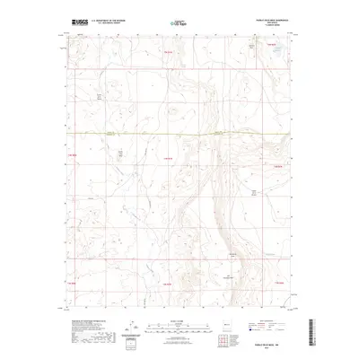
2023 Map of Pueblo Viejo Mesa
USGS Topo · Published 2023About this map
Pueblo Viejo Mesa dominates this high-desert landscape in central New Mexico, marking a significant geological rise along the border of Cibola and Socorro counties. The drainage pattern is defined by the winding course of Gallegos Creek, which carves through the arid terrain, supported by occasional water sources such as Victorino Spring and Laguna Del Oro. These scattered water features were historically vital for land use in an area characterized by massive flat-topped landforms like Victorino Mesa and Tres Hermanos Mesa. The topography is deeply incised by canyons, including Cañon de la Mosca and Cañon de la Ternera, while access is maintained by a sparse network of unpaved routes like Red Lake Rd and Merch Rd. The presence of features such as Waterbury Draw and Foothill Tank illustrates the ongoing importance of managing seasonal runoff in this high-altitude environment.
Find a feature on this map
13 named features on this map. Tap any name to fly to it.
Don’t see what you’re looking for? This feature index may not catch every label — zoom into the map to look around manually.
Map Details
Editions of this 2023 Pueblo Viejo Mesa Map
This is the sole edition of this map. No revisions or reprints were ever made.
Other maps of this area

1917 · Cerro Verde
USGS Topo · 1:125,000

1917 · Broom Mountain
USGS Topo · 1:125,000

1954 · Socorro
USGS Topo · 1:250,000

1958 · Socorro
USGS Topo · 1:250,000

1962 · Socorro
USGS Topo · 1:250,000

1964 · Table Mountain
USGS Topo · 1:24,000

1964 · Wiley Mesa
USGS Topo · 1:24,000

1964 · Field Ranch
USGS Topo · 1:24,000
1964 · Cerro Del Oro
USGS Topo · 1:24,000
1964 · Mecate Meadow
USGS Topo · 1:24,000