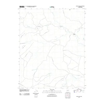
2010 Map of Puerco Dam
USGS Topo · Published 2010About this map
Rio Puerco defines this desert landscape as it winds through the heart of the Laguna Indian Res, marking a region shaped by ephemeral watercourses and ranching life. The map details the varied topography of Sandoval County, from the heights of Mesa Prieta to the deep cuts of Salado Canyon and Cañon de la Agua Blanca. Human presence is anchored by local landmarks such as Las Lagunitas Ranch and the Benavidez Ranch, alongside infrastructure like the Puerco Dam. The network of arroyos, including Arroyo Cuervo and Arroyo Bernardo, illustrates the complex drainage system feeding into the main river valley. This survey captures the intersection of sovereign tribal lands and private ranching interests at a time when traditional crossings, such as Cuervo Crossing, remained vital geographical markers.
Find a feature on this map
17 named features on this map. Tap any name to fly to it.
Don’t see what you’re looking for? This feature index may not catch every label — zoom into the map to look around manually.
Map Details
Editions of this 2010 Puerco Dam Map
This is the sole edition of this map. No revisions or reprints were ever made.
Other maps of this area

1883 · Mt. Taylor
USGS Topo · 1:250,000

1886 · Mt. Taylor
USGS Topo · 1:250,000

1888 · Bernalillo
USGS Topo · 1:125,000

1889 · Albuquerque
USGS Topo · 1:125,000

1892 · Mt. Taylor
USGS Topo · 1:250,000

1893 · Albuquerque
USGS Topo · 1:125,000

1899 · Mt. Taylor
USGS Topo · 1:250,000

1954 · Herrera
USGS Topo · 1:24,000

1954 · Sky Village
USGS Topo · 1:24,000
1954 · Benavidez Ranch
USGS Topo · 1:24,000