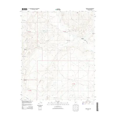
2013 Map of Puerco Dam
USGS Topo · Published 2013About this map
Las Lagunitas Ranch and the isolated Cuervo Crossing anchor this high-desert landscape in Sandoval County, where the intricate drainage systems of the Rio Puerco basin define the local geography. The map illustrates a deeply dissected terrain dominated by the massive Mesa Prieta to the north and the complex network of the Laguna Indian Res boundaries. A series of deep incisions, including Salado Canyon and Cañon Cuervo, reveal the erosive power of seasonal waterways like Salado Creek and Arroyo Nine. This 2013 survey provides a detailed look at the rural land management and hydrological features of the region, from the named Cañada Nervio to the specific canyon floors such as Cañon de la Agua Blanca.
Find a feature on this map
18 named features on this map. Tap any name to fly to it.
Don’t see what you’re looking for? This feature index may not catch every label — zoom into the map to look around manually.
Map Details
Editions of this 2013 Puerco Dam Map
This is the sole edition of this map. No revisions or reprints were ever made.
Other maps of this area

1883 · Mt. Taylor
USGS Topo · 1:250,000

1886 · Mt. Taylor
USGS Topo · 1:250,000

1888 · Bernalillo
USGS Topo · 1:125,000

1889 · Albuquerque
USGS Topo · 1:125,000

1892 · Mt. Taylor
USGS Topo · 1:250,000

1893 · Albuquerque
USGS Topo · 1:125,000

1899 · Mt. Taylor
USGS Topo · 1:250,000

1954 · Herrera
USGS Topo · 1:24,000

1954 · Sky Village
USGS Topo · 1:24,000
1954 · Benavidez Ranch
USGS Topo · 1:24,000