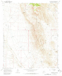
1965 Map of Puertecito Gap
USGS Topo · Published 1982About this map
The Magdalena Mountains dominate this landscape, defined by the prominent ridge of the Devils Backbone and heights like Bern Peak and Horse Mountain. At the time of this mid-1960s fieldwork, the area served primarily as ranching and mining land, evidenced by scattered prospects and a Mine near Puertecito Gap. Water management is the primary sign of human activity in this arid terrain, with a network of wells and tanks such as Copper Canyon Well, Blue Well, and Poniente Tank supporting livestock and isolated outposts like V L Ranch and Rienhardt Ranch.
Find a feature on this map
34 named features on this map. Tap any name to fly to it.
Don’t see what you’re looking for? This feature index may not catch every label — zoom into the map to look around manually.
Map Details
Editions of this 1965 Puertecito Gap Map
2 editions found
Other maps of this area

1954 · Tularosa
USGS Topo · 1:250,000

1958 · Tularosa
USGS Topo · 1:250,000

1961 · Hickman Ranch
USGS Topo · 1:24,000

1961 · Fort Craig
USGS Topo · 1:24,000

1964 · San Juan Peak
USGS Topo · 1:24,000
1965 · Tenmile Hill
USGS Topo · 1:24,000
1965 · Squaw Peak
USGS Topo · 1:24,000
1965 · Puertecito Gap
USGS Topo · 1:24,000
1965 · South Baldy
USGS Topo · 1:24,000
1965 · Molino Peak
USGS Topo · 1:24,000