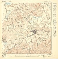
1949 Map of Puerto Real NE
USGS Topo · Published 1949About this map
The town of Cabo Rojo serves as the focal point for this late-1940s topographic study, showing a transition from the agricultural interior to the coastal western edge of Puerto Rico. The American Railroad Company of Porto Rico cuts a distinctive path through the landscape, linking the urban center with the surrounding barrios. Near the coastline of the Pasaje de Mona, the fishing village of Puerto Real and the coastal settlement of Joyuda neighbor the expansive Laguna Joyuda, illustrating the region's historical reliance on marine geography.
Find a feature on this map
36 named features on this map. Tap any name to fly to it.
Don’t see what you’re looking for? This feature index may not catch every label — zoom into the map to look around manually.
Map Details
Editions of this 1949 Puerto Real NE Map
This is the sole edition of this map. No revisions or reprints were ever made.
Other maps of this area

1935 · Puerto Real
USGS Topo · 1:25,000

1937 · San German
USGS Topo · 1:25,000

1937 · Puerto Real
USGS Topo · 1:25,000

1939 · Mayaguez
USGS Topo · 1:30,000

1941 · San German
USGS Topo · 1:30,000

1941 · Puerto Real
USGS Topo · 1:30,000

1941 · Rosario
USGS Topo · 1:30,000

1942 · Rosario
USGS Topo · 1:30,000
1947 · Mayaguez
USGS Topo · 1:30,000
1949 · Puerto Real SE
USGS Topo · 1:10,000
Featured Places
- Cabo Rojo
- Reparto Vista Verde, Cabo Rojo
- Sector Souchet, Cabo Rojo
- Monte Grande, Cabo Rojo
- Llanos Tuna, Cabo Rojo