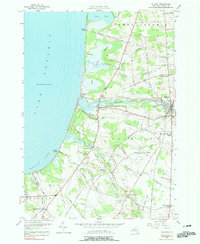
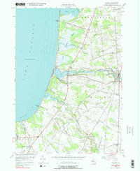
1956 Map of Pulaski
USGS Topo · Published 1990About this map
Salmon River dominates this mid-century survey as it flows through the village of Pulaski, eventually reaching Lake Ontario at Port Ontario. The shoreline is a study in recreational and maritime history, featuring the Selkirk Lighthouse and the expansive Selkirk State Park just north of Mexico Bay. Inland, the landscape is defined by its rural crossroads and local institutions, including the Academy and Central School and various family-named intersections like Tinker Tavern Corner and Malby Corners. A network of small waterways, such as Grindstone Creek and Deer Creek, carves through the terrain, supporting the agricultural character of the Richland and Sandy Creek townships. Genealogists will find numerous burial grounds preserved here, from the North Street Road Cemetery to the South Richland Cemetery, alongside scattered community hubs like Daysville and Rainbow Shores.
Find a feature on this map
66 named features on this map. Tap any name to fly to it.
Don’t see what you’re looking for? This feature index may not catch every label — zoom into the map to look around manually.
Map Details
Editions of this 1956 Pulaski Map
5 editions found
Other maps of this area

1895 · Pulaski
USGS Topo · 1:62,500

1900 · Fulton
USGS Topo · 1:62,500

1905 · Mexico
USGS Topo · 1:62,500

1942 · Sandy Creek
USGS Topo · 1:24,000

1943 · Pulaski
USGS Topo · 1:31,680

1943 · New Haven
USGS Topo · 1:31,680

1943 · Richland
USGS Topo · 1:31,680

1943 · Texas
USGS Topo · 1:31,680

1943 · Mexico
USGS Topo · 1:31,680
1943 · Ellisburg
USGS Topo · 1:31,680