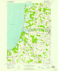
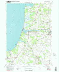
1956 Map of Pulaski
USGS Topo · Published 1958About this map
The Salmon River flows westward through the heart of this mid-century lakeshore landscape, meeting Lake Ontario near the historic village of Port Ontario. This 1956 topography details a coastal region defined by its diverse wetlands and waterways, from the Selkirk Shores State Park along the Mexico Bay coastline to the meandering reaches of Grindstone Creek and Deer Creek. The inland area is organized around numerous rural junctions such as Bethel Corners, Daysville, and Tylers Corner, reflecting a long-established agricultural settlement pattern.
Find a feature on this map
71 named features on this map. Tap any name to fly to it.
Don’t see what you’re looking for? This feature index may not catch every label — zoom into the map to look around manually.
Map Details
Editions of this 1956 Pulaski Map
5 editions found
Other maps of this area

1895 · Pulaski
USGS Topo · 1:62,500

1900 · Fulton
USGS Topo · 1:62,500

1905 · Mexico
USGS Topo · 1:62,500

1942 · Sandy Creek
USGS Topo · 1:24,000

1943 · Pulaski
USGS Topo · 1:31,680

1943 · New Haven
USGS Topo · 1:31,680

1943 · Richland
USGS Topo · 1:31,680

1943 · Texas
USGS Topo · 1:31,680

1943 · Mexico
USGS Topo · 1:31,680
1943 · Ellisburg
USGS Topo · 1:31,680