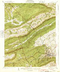
1940 Map of Pulaski
USGS Topo · Published 1940About this map
The industrial and topographic character of the Appalachian landscape is clearly defined in this 1940 survey, centered on the hub of Pulaski near the southern edge. The area is dominated by the massive parallel ridges of Walker Mountain and Brushy Mountain, which channel local movement and development through narrow gaps and valleys. Resource extraction and rural community life are evident through the presence of the Stange Mines and Empire Mine, while the infrastructure of the Norfolk and Western railroad services the town. Away from the rail lines, the landscape is dotted with small institutional landmarks such as Weisendon Ch and the Mill Iron Sch, reflecting the distributed settlement patterns in the Jefferson National Forest and surrounding ridges. The survey captures a moment when the Pulaski Reservoir provided essential water for the growing town, and high-elevation landmarks like the Dismal Peak Fire Tower provided vital regional oversight.
Find a feature on this map
84 named features on this map. Tap any name to fly to it.
Don’t see what you’re looking for? This feature index may not catch every label — zoom into the map to look around manually.
Map Details
Editions of this 1940 Pulaski Map
3 editions found

Other maps of this area

1887 · Pocahontas
USGS Topo · 1:125,000

1889 · Hillsville
USGS Topo · 1:125,000

1889 · Wytheville
USGS Topo · 1:125,000

1890 · Dublin
USGS Topo · 1:125,000

1891 · Pocahontas
USGS Topo · 1:125,000

1891 · Dublin
USGS Topo · 1:125,000

1892 · Hillsville
USGS Topo · 1:125,000

1892 · Wytheville
USGS Topo · 1:125,000

1894 · Pocahontas
USGS Topo · 1:125,000

1895 · Pocahontas
USGS Topo · 1:125,000