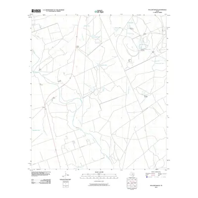
2010 Map of Pulliam Ranch
USGS Topo · Published 2010About this map
The Nueces River winds through this cattle-ranching corridor of Zavala County, where a network of seasonal creeks and man-made water tanks defines the land use. The map illustrates a landscape of large estates, including the Pulliam Ranch, Cain Ranch, and Lyles Ranch, which are supported by numerous water management features like Palmer Tank Dam and Peterson Lake Dam. The presence of the Uvalde Test Track in the eastern portion of the quadrangle introduces a modern industrial footprint to this traditionally agricultural region. Transportation and transit points are marked by A B Junction and Washer, while the drainage of the area is further characterized by Sand Ridge Creek and the meandering Camp Lake Slough. Genealogists and local historians can trace family-named landmarks such as the Kennedy Windmill and Palmer Ranch, which provide evidence of long-standing ranching operations in this part of South Texas.
Find a feature on this map
29 named features on this map. Tap any name to fly to it.
Don’t see what you’re looking for? This feature index may not catch every label — zoom into the map to look around manually.
Map Details
Editions of this 2010 Pulliam Ranch Map
This is the sole edition of this map. No revisions or reprints were ever made.
Other maps of this area

1898 · Uvalde
USGS Topo · 1:125,000

1899 · Uvalde
USGS Topo · 1:125,000

1939 · La Pryor
USGS Topo · 1:62,500

1953 · Crystal City
USGS Topo · 1:250,000

1954 · San Antonio
USGS Topo · 1:250,000

1955 · Crystal City
USGS Topo · 1:250,000

1957 · San Antonio
USGS Topo · 1:250,000

1957 · Batesville
USGS Topo · 1:62,500
1960 · Hacienda
USGS Topo · 1:24,000

1960 · Pulliam Ranch
USGS Topo · 1:24,000