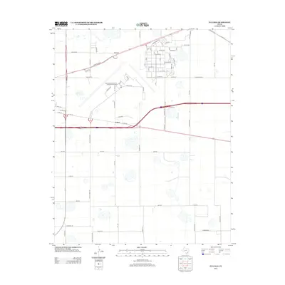
2012 Map of Pullman
USGS Topo · Published 2012About this map
The Rick Husband Amarillo International Airport dominates the north-central portion of this High Plains landscape, serving as a focal point for the regional infrastructure. This survey captures a mix of industrial and transit-oriented development, particularly around the settlements of Folsom and Pullman. The area is defined by its rectilinear grid of country roads and significant transportation corridors, including the I-40 Bus Rt and E Amarillo Blvd. Beyond the airport grounds and residential pockets like those near Golden Dr, the terrain remains largely open, characteristic of the Texas Panhandle's expansive geography. Local transit routes such as S Fm-1912 and Ranch Road 2575 link these outlying communities to the broader Amarillo metro area, providing a clear picture of the region's 21st-century spatial organization.
Find a feature on this map
56 named features on this map. Tap any name to fly to it.
Don’t see what you’re looking for? This feature index may not catch every label — zoom into the map to look around manually.
Map Details
Editions of this 2012 Pullman Map
This is the sole edition of this map. No revisions or reprints were ever made.
Other maps of this area

1934 · Cliffside
USGS Topo · 1:62,500

1936 · Cliffside
USGS Topo · 1:62,500

1953 · Pleasant Valley
USGS Topo · 1:24,000

1953 · Mayer
USGS Topo · 1:24,000

1953 · Sevenmile Basin
USGS Topo · 1:24,000

1954 · Amarillo
USGS Topo · 1:250,000

1956 · Amarillo East
USGS Topo · 1:24,000

1956 · Washburn
USGS Topo · 1:24,000

1956 · Thomas Ranch
USGS Topo · 1:24,000

1956 · Pullman
USGS Topo · 1:24,000