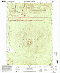
1999 Map of Pumice Desert East
USGS Topo · Published 2002About this map
Crater Lake National Park dominates the southern half of this landscape, where the volcanic profile of Timber Crater rises as a central landmark. The terrain transitions north into the Winema National Forest and the Mount Thielsen Wilderness, reflecting a high-altitude environment shaped by ancient eruptions. The presence of the Pumice Desert in the west illustrates the stark geological legacy of the region, where thick volcanic deposits have limited vegetation growth for millennia.
Find a feature on this map
24 named features on this map. Tap any name to fly to it.
Don’t see what you’re looking for? This feature index may not catch every label — zoom into the map to look around manually.
Map Details
Editions of this 1999 Pumice Desert East Map
This is the sole edition of this map. No revisions or reprints were ever made.
Other maps of this area

1889 · Klamath
USGS Topo · 1:250,000

1891 · Ashland
USGS Topo · 1:250,000

1893 · Ashland
USGS Topo · 1:250,000

1894 · Klamath
USGS Topo · 1:250,000

1897 · Ashland
USGS Topo · 1:250,000

1917 · Diamond Lake
USGS Topo · 1:125,000

1935 · Chemult
USGS Topo · 1:96,000

1941 · Chemult
USGS Topo · 1:125,000

1955 · Crescent
USGS Topo · 1:250,000

1955 · Klamath Falls
USGS Topo · 1:250,000