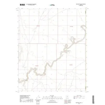
2018 Map of Pump Ranch Tank
USGS Topo · Published 2018About this map
Clear Cr snakes through the high desert landscape of central Arizona, defining the drainage patterns of this arid region. The terrain is marked by deep incisions and prominent overlooks, such as the geological formation at Relic Point and the winding corridor of Pablo Canyon. Water management is central to the land's utility, evidenced by localized catchment systems including Pump Ranch Tank and Sims Tank. These features reflect a history of ranching infrastructure designed to capture seasonal runoff across the high plateau. To the south, the landscape transitions into broad ephemeral washes like Sand Draw, showcasing the transition from rocky canyons to wide alluvial plains. This 2018 survey by the U.S. Geological Survey documents the interface between Coconino and Navajo counties, capturing a specialized environment where topography dictates movement and resource use.
Find a feature on this map
11 named features on this map. Tap any name to fly to it.
Don’t see what you’re looking for? This feature index may not catch every label — zoom into the map to look around manually.
Map Details
Editions of this 2018 Pump Ranch Tank Map
This is the sole edition of this map. No revisions or reprints were ever made.
Other maps of this area

1886 · Holbrook
USGS Topo · 1:250,000

1893 · Holbrook
USGS Topo · 1:250,000

1954 · Holbrook
USGS Topo · 1:250,000

1955 · Sunset Knoll 2 SW
USGS Topo · 1:24,000
1955 · Sunset Knoll 2 NW
USGS Topo · 1:24,000

1955 · Sunset Knoll 2 SE
USGS Topo · 1:24,000

1955 · Sunset Pass
USGS Topo · 1:62,500

1957 · Holbrook
USGS Topo · 1:250,000

1958 · Holbrook
USGS Topo · 1:250,000

1960 · Holbrook
USGS Topo · 1:250,000