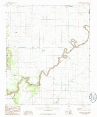
1986 Map of Pump Ranch Tank
USGS Topo · Published 1986About this map
Clear Creek winds through the center of this high plateau landscape along the border of Coconino and Navajo Counties. This 1980s survey illustrates a region defined by livestock water management and topographic extremes, where numerous named catchments like Autrey Tank, Sims Tank, and Carpenter Tank were essential for ranching operations. The terrain is dominated by the prominence of East Sunset Mountain to the west and the sharp relief of Relic Point, which overlooks the deeply incised creek bed. To the north, Moonlight Bay Reservoir represents a significant man-made water source in this arid environment. The map also documents drainage patterns including Sand Draw and Pablo Canyon, alongside several ranching structures marked simply as Corral, offering a look at the rural infrastructure in Northern Arizona toward the end of the twentieth century.
Find a feature on this map
12 named features on this map. Tap any name to fly to it.
Don’t see what you’re looking for? This feature index may not catch every label — zoom into the map to look around manually.
Map Details
Editions of this 1986 Pump Ranch Tank Map
This is the sole edition of this map. No revisions or reprints were ever made.
Other maps of this area

1886 · Holbrook
USGS Topo · 1:250,000

1893 · Holbrook
USGS Topo · 1:250,000

1954 · Holbrook
USGS Topo · 1:250,000

1955 · Sunset Knoll 2 SW
USGS Topo · 1:24,000
1955 · Sunset Knoll 2 NW
USGS Topo · 1:24,000

1955 · Sunset Knoll 2 SE
USGS Topo · 1:24,000

1955 · Sunset Pass
USGS Topo · 1:62,500

1957 · Holbrook
USGS Topo · 1:250,000

1958 · Holbrook
USGS Topo · 1:250,000

1960 · Holbrook
USGS Topo · 1:250,000