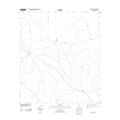
2013 Map of Pumpville
USGS Topo · Published 2013About this map
Pumpville anchors this West Texas landscape in the early twenty-first century, serving as a primary point of reference in an area defined by wide-open ranching and seasonal drainages. The topography is marked by a network of dry watercourses, most notably the winding paths of Osman Draw and Little Osman Draw, which shape the local contours alongside Antonio Cr. Transportation is centered on Ranch Road 1865, which intersects the rail line at Pumpville, while Arledge Ranch Rd provides access to the interior. The map documents several significant family-named estates that have defined the local economy and land use for generations, including Arledge Ranch, Owen Ranch, and Rancho Grande. In the southeastern corner, the label for Osman identifies a specific point of historical interest along the railway and drainage system.
Find a feature on this map
15 named features on this map. Tap any name to fly to it.
Don’t see what you’re looking for? This feature index may not catch every label — zoom into the map to look around manually.
Map Details
Editions of this 2013 Pumpville Map
This is the sole edition of this map. No revisions or reprints were ever made.
Other maps of this area

1943 · Malvado
USGS Topo · 1:62,500

1943 · Langtry
USGS Topo · 1:62,500

1944 · Malvado
USGS Topo · 1:62,500

1954 · Sonora
USGS Topo · 1:250,000

1958 · Sonora
USGS Topo · 1:250,000

1958 · Del Rio
USGS Topo · 1:250,000

1964 · Del Rio
USGS Topo · 1:250,000

1970 · Little Fielder Draw
USGS Topo · 1:24,000

1973 · Langtry
USGS Topo · 1:24,000
1973 · Harkell Canyon
USGS Topo · 1:24,000