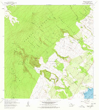
1966 Map of Punaluu
USGS Topo · Published 1978About this map
Kahuku Lava Flow of 1850 defines the northwestern reaches of this coastal landscape, illustrating the raw volcanic history of the Kau District. Toward the shoreline, the coastal settlements of Ninole and Punaluu are shown during a period when the Old Railroad Grade and Ninole-Wailau Homesteads still clearly marked the local infrastructure. Cultural sites of significant importance, including Kaneeleele Heiau and Kaieie Heiau, sit near the Pacific Ocean, providing a record of indigenous history adjacent to modern features like Punaluu Beach Park.
Find a feature on this map
60 named features on this map. Tap any name to fly to it.
Don’t see what you’re looking for? This feature index may not catch every label — zoom into the map to look around manually.
Map Details
Editions of this 1966 Punaluu Map
2 editions found
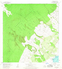
Other maps of this area

1921 · Kilauea
USGS Topo · 1:62,500

1923 · Pahala
USGS Topo · 1:62,500

1924 · Kilauea
USGS Topo · 1:62,500

1924 · Honuapo
USGS Topo · 1:62,500

1928 · Mauna Loa
USGS Topo · 1:62,500

1954 · Hawaii South
USGS Topo · 1:250,000

1959 · Hawaii South
USGS Topo · 1:250,000

1961 · Hawaii South
USGS Topo · 1:250,000

1962 · Hawaii South
USGS Topo · 1:250,000

1962 · Kahuku Ranch
USGS Topo · 1:24,000