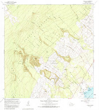
1982 Map of Punaluu
USGS Topo · Published 1984About this map
The Kahuku Forest Reserve blankets this coastal landscape, where the volcanic slopes of the Big Island descend toward the Pacific Ocean. This 1982 revision documents the transition from early plantation history to contemporary recreational and agricultural uses. Along the coastline, the Punaluu Harbor area serves as a focal point, featuring the Punaluu Beach Park and the nearby Golf Club. Cultural history is prominently represented by the Kaieie Heiau and Kaneeleele Heiau, as well as the Kapukini Ruin. Further inland, the legacy of the sugar era is visible in the footprint of the Ninole-Wailau Homesteads and former settlement locations like Middle Moaula Camp (Site) and Higashi Camp (Site). An Old Railroad Grade traces the lower elevations near Ninole, marking the path of former industrial transport through the Ninole Gulch.
Find a feature on this map
69 named features on this map. Tap any name to fly to it.
Don’t see what you’re looking for? This feature index may not catch every label — zoom into the map to look around manually.
Map Details
Editions of this 1982 Punaluu Map
2 editions found
Other maps of this area

1921 · Kilauea
USGS Topo · 1:62,500

1923 · Pahala
USGS Topo · 1:62,500

1924 · Kilauea
USGS Topo · 1:62,500

1924 · Honuapo
USGS Topo · 1:62,500

1928 · Mauna Loa
USGS Topo · 1:62,500

1954 · Hawaii South
USGS Topo · 1:250,000

1959 · Hawaii South
USGS Topo · 1:250,000

1961 · Hawaii South
USGS Topo · 1:250,000

1962 · Hawaii South
USGS Topo · 1:250,000

1962 · Kahuku Ranch
USGS Topo · 1:24,000