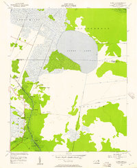
1954 Map of Pungo Lake
USGS Topo · Published 1957About this map
Pungo Lake dominates the center of this 1950s landscape, straddling the Washington and Hyde County line. This region is characterized by a complex network of artificial waterways and natural ridges, where the Pungo River and Pungo Lake Canal provide essential drainage for the low-lying terrain. The map captures an era of river-based commerce and travel, evidenced by numerous small water-access points such as Elbow Landing, Davis Landing, and Indian Landing along the western boundary with Beaufort County.
Find a feature on this map
31 named features on this map. Tap any name to fly to it.
Don’t see what you’re looking for? This feature index may not catch every label — zoom into the map to look around manually.
Map Details
Editions of this 1954 Pungo Lake Map
2 editions found
Other maps of this area

1914 · Belhaven
USGS Topo · 1:48,000

1916 · Belhaven
USGS Topo · 1:62,500

1943 · Columbia
USGS Topo · 1:125,000

1943 · Plymouth
USGS Topo · 1:125,000

1951 · Belhaven
USGS Topo · 1:24,000

1951 · Pantego
USGS Topo · 1:24,000

1951 · Ponzer
USGS Topo · 1:24,000

1953 · Rocky Mount
USGS Topo · 1:250,000

1954 · Rocky Mount
USGS Topo · 1:250,000

1954 · Plymouth East
USGS Topo · 1:24,000