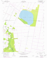
1954 Map of Pungo Lake
USGS Topo · Published 1977About this map
Pungo Lake dominates the upper half of this coastal plain survey, situated on the border of Washington and Hyde Counties. The landscape is defined by an extensive network of drainage infrastructure, including the Pungo River Canal, Oregon Canal, and Pungo Lake Canal, which supported the reclamation of this low-lying territory for agriculture and settlement. Along the western edge of the lake and the Pungo River Canal, a series of landings and small ridges mark the habitable ground, such as Elbow Landing, Davis Landing, and White Oak Landing.
Find a feature on this map
29 named features on this map. Tap any name to fly to it.
Don’t see what you’re looking for? This feature index may not catch every label — zoom into the map to look around manually.
Map Details
Editions of this 1954 Pungo Lake Map
2 editions found
Other maps of this area

1914 · Belhaven
USGS Topo · 1:48,000

1916 · Belhaven
USGS Topo · 1:62,500

1943 · Columbia
USGS Topo · 1:125,000

1943 · Plymouth
USGS Topo · 1:125,000

1951 · Belhaven
USGS Topo · 1:24,000

1951 · Pantego
USGS Topo · 1:24,000

1951 · Ponzer
USGS Topo · 1:24,000

1953 · Rocky Mount
USGS Topo · 1:250,000

1954 · Rocky Mount
USGS Topo · 1:250,000

1954 · Plymouth East
USGS Topo · 1:24,000