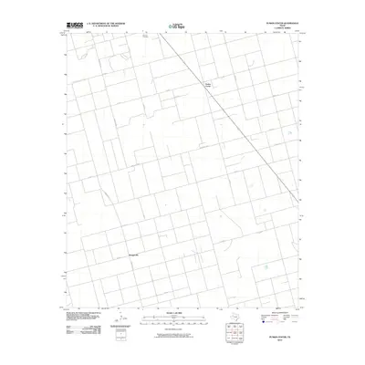
2010 Map of Punkin Center
USGS Topo · Published 2010About this map
Punkin Center and Mungerville anchor this West Texas landscape, defined by a rigid grid of county roads and ranch-to-market routes that reflect the area's agricultural organization. Located in Dawson County, the terrain is sparsely populated, with the Fairview Cemetery serving as a significant landmark for genealogical research. The layout of roads like Ranch Rd 829 and Co Rd 9 illustrates the systematic division of the land into large parcels characteristic of the Llano Estacado. This 2010 survey by the U.S. Geological Survey captures the quiet, expansive character of the region, where a few small settlements and scattered homesteads are connected by long, straight stretches of pavement and dirt. For those researching local family history or land use patterns, the map identifies specific junction points and rural road names that have remained largely consistent for generations.
Find a feature on this map
15 named features on this map. Tap any name to fly to it.
Don’t see what you’re looking for? This feature index may not catch every label — zoom into the map to look around manually.
Map Details
Editions of this 2010 Punkin Center Map
This is the sole edition of this map. No revisions or reprints were ever made.
Other maps of this area

1954 · Hobbs
USGS Topo · 1:250,000

1954 · Big Spring
USGS Topo · 1:250,000

1958 · Big Spring
USGS Topo · 1:250,000

1958 · Hobbs
USGS Topo · 1:250,000

1968 · Lamesa North
USGS Topo · 1:24,000

1969 · Welch East
USGS Topo · 1:24,000

1969 · Gooch Lake
USGS Topo · 1:24,000

1969 · Welch SW
USGS Topo · 1:24,000

1969 · Punkin Center
USGS Topo · 1:24,000
1969 · Welch West
USGS Topo · 1:24,000