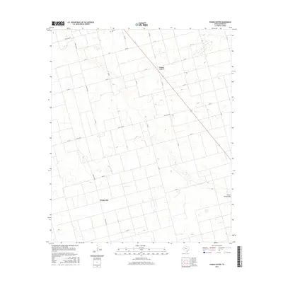
2016 Map of Punkin Center
USGS Topo · Published 2016About this map
Punkin Center and Mungerville anchor this Dawson County landscape, characterized by the expansive agricultural grid of West Texas. This 2016 survey highlights a region shaped by ranch roads and section lines, with Ranch Rd 829 and Ranch Rd 1066 providing primary access through the flat terrain. The ephemeral Sulphur Springs Draw meanders across the eastern portion of the sheet, providing a rare natural break in the geometric road network of county routes like Co Rd G and Co Rd 10. For those researching local heritage, the inclusion of Fairview and the Fairview Cem offers a focal point for genealogical study. The map illustrates a contemporary rural environment where historic settlement names persist alongside modern infrastructure and land management.
Find a feature on this map
24 named features on this map. Tap any name to fly to it.
Don’t see what you’re looking for? This feature index may not catch every label — zoom into the map to look around manually.
Map Details
Editions of this 2016 Punkin Center Map
This is the sole edition of this map. No revisions or reprints were ever made.
Other maps of this area

1954 · Hobbs
USGS Topo · 1:250,000

1954 · Big Spring
USGS Topo · 1:250,000

1958 · Big Spring
USGS Topo · 1:250,000

1958 · Hobbs
USGS Topo · 1:250,000

1968 · Lamesa North
USGS Topo · 1:24,000

1969 · Welch East
USGS Topo · 1:24,000

1969 · Gooch Lake
USGS Topo · 1:24,000

1969 · Welch SW
USGS Topo · 1:24,000

1969 · Punkin Center
USGS Topo · 1:24,000
1969 · Welch West
USGS Topo · 1:24,000