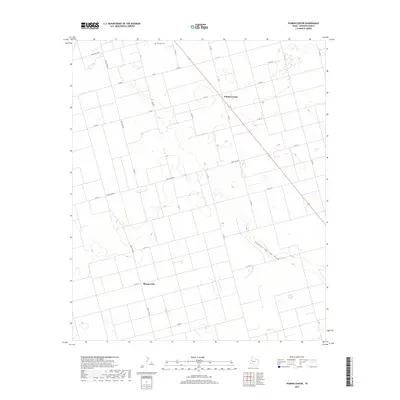
2019 Map of Punkin Center
USGS Topo · Published 2019About this map
Punkin Center and Mungerville anchor this Dawson County landscape, illustrating the persistent grid of the Llano Estacado. The area is defined by a dense network of local roads including Co Rd 9 and Co Rd 13, which serve the expansive agricultural tracts typical of this part of West Texas. Historically significant landmarks such as Fairview Cem provide a focal point for genealogical interest in an otherwise sparsely populated region. The natural topography is subtly interrupted by the path of Sulphur Springs Draw, which cuts diagonally across the southeastern portion of the quadrangle. This drainage feature represents the primary break in the flat terrain, where seasonal water once influenced local settlement patterns and cattle ranching. Modern connectivity is maintained by Highway 137 and several ranch-to-market style routes like Ranch Rd 1064.
Find a feature on this map
26 named features on this map. Tap any name to fly to it.
Don’t see what you’re looking for? This feature index may not catch every label — zoom into the map to look around manually.
Map Details
Editions of this 2019 Punkin Center Map
This is the sole edition of this map. No revisions or reprints were ever made.
Other maps of this area

1954 · Hobbs
USGS Topo · 1:250,000

1954 · Big Spring
USGS Topo · 1:250,000

1958 · Big Spring
USGS Topo · 1:250,000

1958 · Hobbs
USGS Topo · 1:250,000

1968 · Lamesa North
USGS Topo · 1:24,000

1969 · Welch East
USGS Topo · 1:24,000

1969 · Gooch Lake
USGS Topo · 1:24,000

1969 · Welch SW
USGS Topo · 1:24,000

1969 · Punkin Center
USGS Topo · 1:24,000
1969 · Welch West
USGS Topo · 1:24,000