
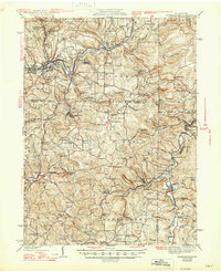
1942 Map of Punxsutawney
USGS Topo · Published 1942About this map
Punxsutawney serves as the industrial and transport hub for this region of Jefferson and Indiana counties, where the Baltimore And Ohio and Pennsylvania railroads intersect. The landscape is defined by the winding course of Mahoning Creek and its many tributaries, supporting numerous small settlements and post offices. This 1942 edition, based on earlier surveys with revisions from 1939, documents a dense network of rural infrastructure including dozens of named schools like Harmony Thomas Sch and Brinkell Sch. These small local schoolhouses and country churches, such as Antioch Ch, were the social anchors for scattered communities like Gipsy, Arcadia, and Rochester Mills. The map also reveals the early coal and clay economy through the proximity of rail sidings to towns like Cloe and Glen Campbell. Genealogists will find significant value in the detailed placement of family-named cemeteries, including Sunderland Cem and Oak Lawn Cem, located along the ridges and valley slopes.
Find a feature on this map
106 named features on this map. Tap any name to fly to it.
Don’t see what you’re looking for? This feature index may not catch every label — zoom into the map to look around manually.
Map Details
Editions of this 1942 Punxsutawney Map
2 editions found
Other maps of this area

1902 · Indiana
USGS Topo · 1:62,500

1902 · Patton
USGS Topo · 1:62,500

1902 · Barnesboro
USGS Topo · 1:62,500

1903 · Curwensville
USGS Topo · 1:62,500

1904 · Barnesboro
USGS Topo · 1:62,500

1904 · Patton
USGS Topo · 1:62,500

1906 · Punxsutawney
USGS Topo · 1:62,500

1909 · Smicksburg
USGS Topo · 1:62,500

1922 · Du Bois
USGS Topo · 1:62,500

1924 · Du Bois
USGS Topo · 1:62,500