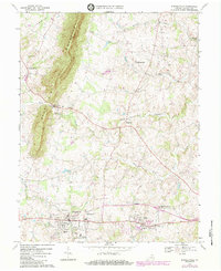
1970 Map of Purcellville
USGS Topo · Published 1984About this map
Short Hill Mountain dominates the western edge of this Loudoun County landscape, casting a long shadow over the rolling valley where the North Fork Catoctin Creek and South Fork Catoctin Creek converge. The mapping reflects a traditional Piedmont agricultural pattern transitioning into a suburban era, centered on the growing town of Purcellville and the nearby village of Hamilton. A dense network of local landmarks illustrates the region's deep social history, from the Ketoctin Ch and Salem Ch Cem to the industrial presence of Hamilton Station. Educational development is prominently noted through the sites of Loudoun Valley High Sch, Purcellville Middle Sch, and the Carver Sch. Small, historic crossroads like Wheatland, Morrisonville, and Hillsboro remain distinct, connected by winding routes and the drainage of Milltown Creek.
Find a feature on this map
34 named features on this map. Tap any name to fly to it.
Don’t see what you’re looking for? This feature index may not catch every label — zoom into the map to look around manually.
Map Details
Editions of this 1970 Purcellville Map
3 editions found
Other maps of this area

1884 · Harpers Ferry
USGS Topo · 1:125,000

1891 · Harpers Ferry
USGS Topo · 1:125,000

1893 · Harpers Ferry
USGS Topo · 1:125,000

1908 · Middletown
USGS Topo · 1:48,000

1910 · Antietam
USGS Topo · 1:62,500

1914 · Martinsburg
USGS Topo · 1:48,000

1916 · Martinsburg
USGS Topo · 1:62,500

1916 · Berryville
USGS Topo · 1:62,500

1939 · Berryville
USGS Topo · 1:48,000

1943 · Bluemont
USGS Topo · 1:24,000