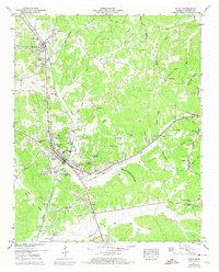
1949 Map of Purdy
USGS Topo · Published 1974About this map
Selmer serves as a central hub in this McNairy County landscape, where the Illinois Central Gulf railroad cuts a diagonal path through the terrain. The map captures the area during a period of transition, with early photogrammetric work from the late 1940s updated with 1970s revisions that highlight the town's expansion. Rural life is anchored by numerous small congregations and burial grounds, such as Bethesda Ch, Mt Zion Church, and the Warren Cem, indicating a well-established network of family-settled communities.
Find a feature on this map
72 named features on this map. Tap any name to fly to it.
Don’t see what you’re looking for? This feature index may not catch every label — zoom into the map to look around manually.
Map Details
Editions of this 1949 Purdy Map
3 editions found
Other maps of this area

1936 · Leapwood
USGS Topo · 1:24,000

1936 · Purdy
USGS Topo · 1:24,000

1936 · Stantonville
USGS Topo · 1:24,000

1936 · Michie
USGS Topo · 1:24,000

1936 · Mt. Peter
USGS Topo · 1:24,000

1949 · Leapwood
USGS Topo · 1:24,000

1949 · Mt. Peter
USGS Topo · 1:24,000

1949 · Purdy
USGS Topo · 1:24,000

1949 · Stantonville
USGS Topo · 1:24,000

1949 · Michie
USGS Topo · 1:24,000