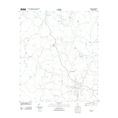
2012 Map of Purvis
USGS Topo · Published 2012About this map
Purvis serves as the primary hub of this 2012 survey, revealing a landscape where the rural Piney Woods of Lamar County meet modern industrial developments like the Black Creek Refinery. The area is characterized by numerous small settlements and family-named landmarks, such as Pine Ridge and Okahola, interspersed with family cemeteries including Hartfield Cem and Boone Cem. Geologically, the terrain is defined by a series of distinct heights such as Red Hill, Lee Hill, and Black Creek Hill, which overlook a complex network of waterways including Beaverdam Cr and Black Cr. The map provides a detailed view of the local infrastructure, from the Po in the center of Purvis to the outlying Southern Pine Hills development. This documentation is particularly valuable for genealogists, as it preserves the locations of smaller burial sites like Coal Town Cem and Nelson Cem which are integral to the local family histories of the region.
Find a feature on this map
164 named features on this map. Tap any name to fly to it.
Don’t see what you’re looking for? This feature index may not catch every label — zoom into the map to look around manually.
Map Details
Editions of this 2012 Purvis Map
This is the sole edition of this map. No revisions or reprints were ever made.
Other maps of this area

1953 · Hattiesburg
USGS Topo · 1:250,000

1958 · Hattiesburg
USGS Topo · 1:250,000

1963 · Rock Hill
USGS Topo · 1:24,000

1964 · Purvis
USGS Topo · 1:24,000

1964 · Hattiesburg
USGS Topo · 1:24,000

1964 · Lumberton
USGS Topo · 1:24,000

1965 · Hattiesburg SW
USGS Topo · 1:24,000

1965 · Dixie
USGS Topo · 1:24,000
1969 · Baxterville
USGS Topo · 1:24,000

1969 · Baxterville NE
USGS Topo · 1:24,000