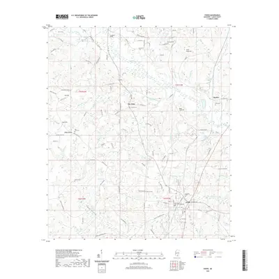
2020 Map of Purvis
USGS Topo · Published 2020About this map
Purvis serves as the focal point for this survey of Lamar County, where the Gamble Chancery Building and Purvis Cem mark the heart of the settlement. The surrounding landscape is defined by its numerous small burial grounds and rural hubs, including Pine Ridge and Okahola. These sites are linked by a dense network of local routes like Purvis Oloh RD and Lookout Tower RD, reflecting the established community structure of the early 21st century.
Find a feature on this map
117 named features on this map. Tap any name to fly to it.
Don’t see what you’re looking for? This feature index may not catch every label — zoom into the map to look around manually.
Map Details
Editions of this 2020 Purvis Map
This is the sole edition of this map. No revisions or reprints were ever made.
Other maps of this area

1953 · Hattiesburg
USGS Topo · 1:250,000

1958 · Hattiesburg
USGS Topo · 1:250,000

1963 · Rock Hill
USGS Topo · 1:24,000

1964 · Purvis
USGS Topo · 1:24,000

1964 · Hattiesburg
USGS Topo · 1:24,000

1964 · Lumberton
USGS Topo · 1:24,000

1965 · Hattiesburg SW
USGS Topo · 1:24,000

1965 · Dixie
USGS Topo · 1:24,000
1969 · Baxterville
USGS Topo · 1:24,000

1969 · Baxterville NE
USGS Topo · 1:24,000