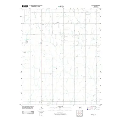
2010 Map of Putnam
USGS Topo · Published 2010About this map
Putnam and Sunset anchor this section of Dewey County, where the agricultural grid is defined by a dense network of sectional roads like e0820 RD and n2270 RD. The landscape is etched by a series of south-flowing drainages including Deer Creek and Horse Creek, which feed into engineered water management systems such as the Barnitz Creek Site 15a Reservoir and Ernst Reservoir. These dams, including the Ernst Dam, highlight the region's reliance on water conservation for its rural economy. For those researching local family histories, the Merck Cemetery in the north and Liberty Cemetery further south provide vital geographical markers for early settlers in this plains environment. The map captures a late 20th-century transition where traditional section-line farming meets modern hydrological engineering.
Find a feature on this map
29 named features on this map. Tap any name to fly to it.
Don’t see what you’re looking for? This feature index may not catch every label — zoom into the map to look around manually.
Map Details
Editions of this 2010 Putnam Map
This is the sole edition of this map. No revisions or reprints were ever made.
Other maps of this area

1955 · Clinton
USGS Topo · 1:250,000

1957 · Clinton
USGS Topo · 1:250,000

1957 · Butler
USGS Topo · 1:62,500

1957 · Clinton
USGS Topo · 1:62,500

1962 · Putnam
USGS Topo · 1:62,500

1962 · Aledo
USGS Topo · 1:62,500

1976 · Butler NE
USGS Topo · 1:24,000

1976 · Clinton NW
USGS Topo · 1:24,000

1976 · Clinton NE
USGS Topo · 1:24,000
1983 · Custer City
USGS Topo · 1:24,000