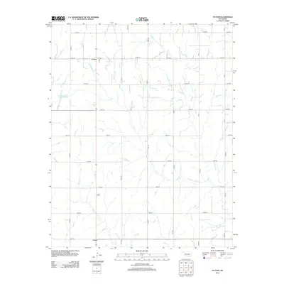
2013 Map of Putnam
USGS Topo · Published 2013About this map
Putnam and Sunset anchor this section of Dewey County, where the plains are etched by a dense network of seasonal and perennial waterways. This 2013 topographic survey captures the area's rural character, dominated by north-south section roads like n2280 RD and a hydraulic landscape defined by Deer Cr and Horse Cr. Local genealogy is anchored by the Merck Cem and Liberty Cem, which sit alongside the quiet grid of county roads. Human-made water management is evident in the presence of the Barnitz Cr Site 15a Reservoir and Ernst Reservoir, illustrating how this agricultural region harnesses the intermittent flow of local creeks like Beaver Cr and Sorter Cr. The map provides a clear picture of Oklahoma's high plains settlement pattern, where small communities remain connected by a geometric road network over undulating terrain.
Find a feature on this map
33 named features on this map. Tap any name to fly to it.
Don’t see what you’re looking for? This feature index may not catch every label — zoom into the map to look around manually.
Map Details
Editions of this 2013 Putnam Map
This is the sole edition of this map. No revisions or reprints were ever made.
Other maps of this area

1955 · Clinton
USGS Topo · 1:250,000

1957 · Clinton
USGS Topo · 1:250,000

1957 · Butler
USGS Topo · 1:62,500

1957 · Clinton
USGS Topo · 1:62,500

1962 · Putnam
USGS Topo · 1:62,500

1962 · Aledo
USGS Topo · 1:62,500

1976 · Butler NE
USGS Topo · 1:24,000

1976 · Clinton NW
USGS Topo · 1:24,000

1976 · Clinton NE
USGS Topo · 1:24,000
1983 · Custer City
USGS Topo · 1:24,000