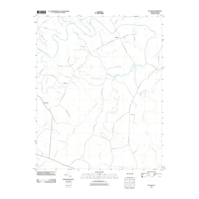
2010 Map of Putnam
USGS Topo · Published 2010About this map
Glendon and Putnam anchor this rural Moore County landscape where the Deep River curves along the northern boundary. The terrain is defined by an intricate network of waterways, including McLendons Creek, Richland Creek, and Lick Creek, which carve through the countryside. The road network reflects a history of family landholdings and community centers, with labels like Kelly Plantation Rd, Putnam Church Rd, and Friendship Church Rd marking the locations of local gathering places and historical estates. In the western portion of the map, the settlement of Parkwood sits near the headwaters of Parkwood Branch, illustrating the typical Piedmont pattern of small hamlets situated between primary drainage basins. This 2010 survey provides a detailed view of the transition from wooded creek bottoms to established rural homesteads.
Find a feature on this map
48 named features on this map. Tap any name to fly to it.
Don’t see what you’re looking for? This feature index may not catch every label — zoom into the map to look around manually.
Map Details
Editions of this 2010 Putnam Map
This is the sole edition of this map. No revisions or reprints were ever made.
Other maps of this area

1942 · Troy
USGS Topo · 1:125,000

1953 · Raleigh
USGS Topo · 1:250,000

1954 · Raleigh
USGS Topo · 1:250,000

1968 · Bennett
USGS Topo · 1:24,000

1970 · Goldston
USGS Topo · 1:24,000

1970 · Bear Creek
USGS Topo · 1:24,000
1974 · Carthage
USGS Topo · 1:24,000

1974 · White Hill
USGS Topo · 1:24,000
1974 · Vass
USGS Topo · 1:24,000

1974 · Putnam
USGS Topo · 1:24,000