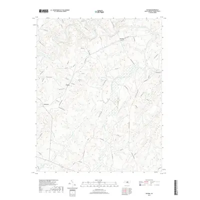
2019 Map of Putnam
USGS Topo · Published 2019About this map
Deep River winds across the northern reaches of this Moore County landscape, defining the topography near the community of Glendon. The terrain is deeply etched by a dense network of watercourses, including McLendons Creek and Richland Cr, which flow through the central and southern portions of the quadrangle. These drainage patterns influenced the early settlement and road layout of the area, as seen in the placement of Putnam and Parkwood. Historic transportation routes are preserved through labels such as Coles Mill Rd and Alston House Rd, which hint at the region's agricultural and industrial foundations. The survey also captures numerous small tributaries like Persimmon Glade Br and Tisons Cr, providing a detailed look at the rural character of this North Carolina Piedmont region in the late 2010s.
Find a feature on this map
65 named features on this map. Tap any name to fly to it.
Don’t see what you’re looking for? This feature index may not catch every label — zoom into the map to look around manually.
Map Details
Editions of this 2019 Putnam Map
This is the sole edition of this map. No revisions or reprints were ever made.
Other maps of this area

1942 · Troy
USGS Topo · 1:125,000

1953 · Raleigh
USGS Topo · 1:250,000

1954 · Raleigh
USGS Topo · 1:250,000

1968 · Bennett
USGS Topo · 1:24,000

1970 · Goldston
USGS Topo · 1:24,000

1970 · Bear Creek
USGS Topo · 1:24,000
1974 · Carthage
USGS Topo · 1:24,000

1974 · White Hill
USGS Topo · 1:24,000
1974 · Vass
USGS Topo · 1:24,000

1974 · Putnam
USGS Topo · 1:24,000