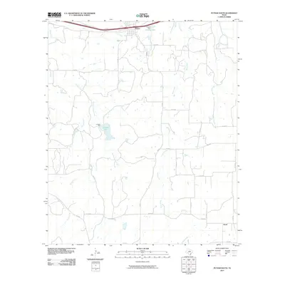
2010 Map of Putnam South
USGS Topo · Published 2010About this map
The town of Putnam anchors the northern edge of this Callahan County landscape, positioned along the vital transportation corridor defined by the I-20 Access Rd. South of the community, the terrain is defined by a dense network of country roads, such as FM 880 and FM 1864, that connect isolated homesteads and ranch lands. This rural character is punctuated by several water management features, most notably La Reata Lake and its corresponding La Reata Dam, alongside Putnam Lake and Putnam Dam. The drainage pattern is heavily dictated by north-flowing waterways like Brushy Creek, Battle Creek, and Cooper Creek, which carve their way through the cattle country of central Texas. At the southeastern corner, the small settlement of Atwell represents the quiet persistence of agricultural communities in this region, linked to the wider area by FM 3265 and Co Rd 467.
Find a feature on this map
30 named features on this map. Tap any name to fly to it.
Don’t see what you’re looking for? This feature index may not catch every label — zoom into the map to look around manually.
Map Details
Editions of this 2010 Putnam South Map
This is the sole edition of this map. No revisions or reprints were ever made.
Other maps of this area

1931 · Baird
USGS Topo · 1:125,000

1932 · Baird
USGS Topo · 1:125,000

1954 · Abilene
USGS Topo · 1:250,000

1958 · Abilene
USGS Topo · 1:250,000

1966 · Scranton
USGS Topo · 1:24,000

1966 · Putnam South
USGS Topo · 1:24,000
1966 · Bernie Lake
USGS Topo · 1:24,000

1966 · Admiral
USGS Topo · 1:24,000
1966 · Putnam North
USGS Topo · 1:24,000
1966 · Jayell
USGS Topo · 1:24,000