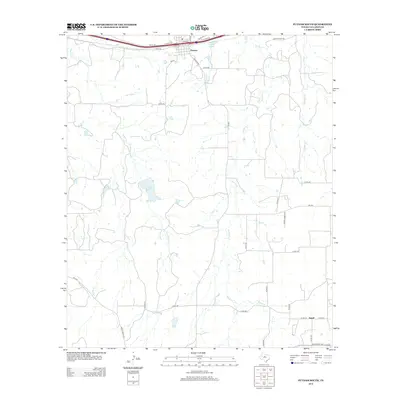
2012 Map of Putnam South
USGS Topo · Published 2012About this map
Putnam sits at the northern edge of this Callahan County landscape, where the local street grid including Ash St and Houston St meets the transit corridor of the Interstate 20 access roads. The terrain to the south is defined by a dendritic network of seasonal waterways, most notably Battle Cr and Brushy Cr, which drain the open ranch land. Small impoundments like La Reata Lake and Putnam Lake suggest the importance of water management in this part of West Texas.
Find a feature on this map
42 named features on this map. Tap any name to fly to it.
Don’t see what you’re looking for? This feature index may not catch every label — zoom into the map to look around manually.
Map Details
Editions of this 2012 Putnam South Map
This is the sole edition of this map. No revisions or reprints were ever made.
Other maps of this area

1931 · Baird
USGS Topo · 1:125,000

1932 · Baird
USGS Topo · 1:125,000

1954 · Abilene
USGS Topo · 1:250,000

1958 · Abilene
USGS Topo · 1:250,000

1966 · Scranton
USGS Topo · 1:24,000

1966 · Putnam South
USGS Topo · 1:24,000
1966 · Bernie Lake
USGS Topo · 1:24,000

1966 · Admiral
USGS Topo · 1:24,000
1966 · Putnam North
USGS Topo · 1:24,000
1966 · Jayell
USGS Topo · 1:24,000