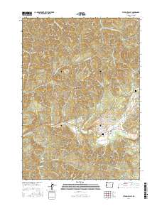
2017 Map of Putnam Valley
USGS Topo · Published 2017About this map
Putnam Valley sits at the center of this 2017 survey, where the drainages of Parker Cr and Elk Creek converge in Douglas County. The landscape is defined by a dense network of forest spurs and ridgelines, including Thistleburn Ridge, Allen Ridge, and Mid Ridge. An intriguing mark of local history appears on the slopes of Lookout Mtn, where the site of a Plane Crash is specifically noted near the ridge line.
Find a feature on this map
73 named features on this map. Tap any name to fly to it.
Don’t see what you’re looking for? This feature index may not catch every label — zoom into the map to look around manually.
Map Details
Editions of this 2017 Putnam Valley Map
This is the sole edition of this map. No revisions or reprints were ever made.
Other maps of this area

1942 · Crow
USGS Topo · 1:62,500

1942 · Roman Nose Mtn
USGS Topo · 1:62,500

1945 · Crow
USGS Topo · 1:62,500

1945 · Roman Nose Mtn
USGS Topo · 1:62,500

1954 · Drain
USGS Topo · 1:62,500

1955 · Elkton
USGS Topo · 1:62,500

1958 · Roseburg
USGS Topo · 1:250,000

1959 · Roseburg
USGS Topo · 1:250,000

1979 · Cottage Grove
USGS Topo · 1:100,000
1984 · Gunter
USGS Topo · 1:24,000