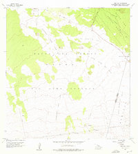
1956 Map of Puu Koli
USGS Topo · Published 1976About this map
Lava Flow of 1843 and the Keamuku Lava Flow dominate this mid-century volcanic landscape on the Big Island. The survey illustrates the stark geomorphology of the high-elevation volcanic plains between Mauna Kea and Mauna Loa, specifically within the Mauna Loa Forest Reserve and Game Reserve and the Mauna Kea Forest Reserve. Transportation through this demanding environment is limited to the historic Saddle Road and the Hilo Kona Road, which traverse the high-altitude Humuula Saddle.
Find a feature on this map
14 named features on this map. Tap any name to fly to it.
Don’t see what you’re looking for? This feature index may not catch every label — zoom into the map to look around manually.
Map Details
Editions of this 1956 Puu Koli Map
2 editions found
Other maps of this area

1927 · Kaohe
USGS Topo · 1:62,500

1930 · Humuula
USGS Topo · 1:62,500

1930 · Kaohe
USGS Topo · 1:62,500

1954 · Hawaii North
USGS Topo · 1:250,000

1956 · Puu Oo
USGS Topo · 1:24,000

1956 · Puu Koli
USGS Topo · 1:24,000
1956 · Puu Ulaula
USGS Topo · 1:24,000

1956 · Keamuku
USGS Topo · 1:24,000

1956 · Puu O Uo
USGS Topo · 1:24,000
1956 · Ahumoa
USGS Topo · 1:24,000