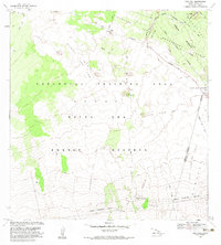
1982 Map of Puu Koli
USGS Topo · Published 1983About this map
Pohakuloa Training Area occupies a significant portion of this high-altitude landscape on the Big Island, illustrating the complex intersection of military land use and geological history. The terrain is defined by massive volcanic events, most notably the Lava Flow of 1843 and the Lava Flow of 1852, which stretch across the Humuula Saddle toward Puu Koli. A dense network of specialized roads and trails, such as Engineer Trail, Aviation Trail, and Infantry Road, crisscross the area, serving the military reservation and the adjacent Mauna Kea Forest Management Area and Game Reserve. These routes reveal the strategic development of the region's interior long after the mid-19th-century eruptions shaped the ground. Conservation and recreation boundaries are also prominent, with the Mauna Loa Forest Reserve protecting the higher elevations.
Find a feature on this map
29 named features on this map. Tap any name to fly to it.
Don’t see what you’re looking for? This feature index may not catch every label — zoom into the map to look around manually.
Map Details
Editions of this 1982 Puu Koli Map
2 editions found
Other maps of this area

1927 · Kaohe
USGS Topo · 1:62,500

1930 · Humuula
USGS Topo · 1:62,500

1930 · Kaohe
USGS Topo · 1:62,500

1954 · Hawaii North
USGS Topo · 1:250,000

1956 · Puu Oo
USGS Topo · 1:24,000

1956 · Puu Koli
USGS Topo · 1:24,000
1956 · Puu Ulaula
USGS Topo · 1:24,000

1956 · Keamuku
USGS Topo · 1:24,000

1956 · Puu O Uo
USGS Topo · 1:24,000
1956 · Ahumoa
USGS Topo · 1:24,000