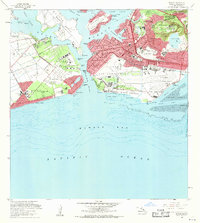
1968 Map of Puuloa
USGS Topo · Published 1970About this map
Ford Island and the intricate lochs of Pearl Harbor anchor this late 1960s survey of Oahu's southern coast. The landscape is dominated by heavy military and aviation infrastructure, from the sprawling Hickam Air Force Base to the memorials of the USS Arizona and USS Utah. The transition from mid-century defense to modern commercial aviation is evident at Honolulu International Airport, featuring its distinct seaplane runway in Keehi Lagoon. Residential growth is visible at Ewa Beach and Foster Village, while the interior terrain is defined by volcanic features like Aliamanu Crater and Makalapa Crater. This edition captures a specific era of Hawaiian history when specialized facilities like the Honolulu Observatory (USC&GS) and the FAA Ewa Radio Station operated alongside massive coastal defense installations such as Fort Weaver and the Fort Kamehameha Military Reservation.
Find a feature on this map
64 named features on this map. Tap any name to fly to it.
Don’t see what you’re looking for? This feature index may not catch every label — zoom into the map to look around manually.
Map Details
Editions of this 1968 Puuloa Map
2 editions found
Other maps of this area

1953 · Schofield Barracks
USGS Topo · 1:24,000

1953 · Honolulu
USGS Topo · 1:24,000

1953 · Ewa
USGS Topo · 1:24,000

1953 · Puuloa
USGS Topo · 1:24,000

1954 · Oahu
USGS Topo · 1:250,000

1954 · Kaneohe
USGS Topo · 1:24,000

1954 · Waipahu
USGS Topo · 1:24,000

1959 · Kaneohe
USGS Topo · 1:24,000

1959 · Honolulu
USGS Topo · 1:24,000

1959 · Waipahu
USGS Topo · 1:24,000