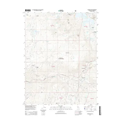
2015 Map of Pyramid Peak
USGS Topo · Published 2015About this map
Strawberry and Sciots Camp sit along the corridor of the El Dorado Fwy, serving as focal points for this high-altitude landscape in the Eldorado National Forest. The map detail follows the S Fork American River as it winds through the southern terrain, marked by historical survey points like the 36 Mile Stone and 39 Mile Stone. To the north, the elevation rises sharply into the Crystal Range, where a dense network of glacial lakes including Lake Aloha, Wrights Lake, and Lyons Lake are clustered beneath peaks like Pyramid Peak and Mt Price. The legendary Pacific Crest National Scenic Trail traverses the eastern edge of the sheet, crossing into the famed Desolation Valley. This layout illustrates the transition from roadside settlements and forest camps to the protected wilderness and granite basins of the high Sierra, preserved through specific landmarks like Lovers Leap and Chimney Flat.
Find a feature on this map
77 named features on this map. Tap any name to fly to it.
Don’t see what you’re looking for? This feature index may not catch every label — zoom into the map to look around manually.
Map Details
Editions of this 2015 Pyramid Peak Map
This is the sole edition of this map. No revisions or reprints were ever made.
Other maps of this area

1889 · Pyramid Peak
USGS Topo · 1:125,000

1891 · Pyramid Peak
USGS Topo · 1:125,000

1895 · Pyramid Peak
USGS Topo · 1:125,000

1896 · Pyramid Peak
USGS Topo · 1:125,000

1947 · Sacramento
USGS Topo · 1:250,000

1948 · Sacramento
USGS Topo · 1:250,000

1951 · Leek Spring Hill
USGS Topo · 1:24,000
1951 · Leek Spring Hill
USGS Topo · 1:62,500
1952 · Kyburz
USGS Topo · 1:24,000
1952 · Loon Lake
USGS Topo · 1:24,000