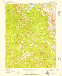
1952 Map of Loon Lake
USGS Topo · Published 1954About this map
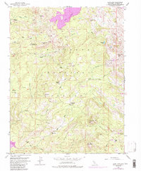
Eldorado National Forest defines this high-elevation Sierra Nevada landscape, where drainage from Loon Lake and Berts Lake feeds the South Fork Rubicon River. The 1952 field check documents a mix of seasonal livestock operations and early forest management infrastructure. Outposts like Van Vleck Ranch, Francis Cow Camp, and Upper Bassi Ranch reflect the era's grazing patterns, while the Schlein Ranger Sta and a private Landing Strip suggest the logistical challenges of monitoring this terrain. To the south, Big Silver Creek winds through areas such as Nigger Wench Flat and Morattini Flat. A network of backcountry routes, including the Jeep Trail and Poison Hole Trail, connects these remote camps and cabins like Millionaire Camp and the Rupley Cabin.
Find a feature on this map
55 named features on this map. Tap any name to fly to it.
Don’t see what you’re looking for? This feature index may not catch every label — zoom into the map to look around manually.
Map Details
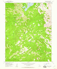
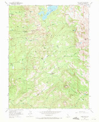
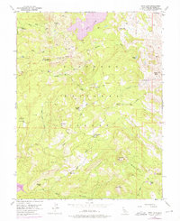
Editions of this 1952 Loon Lake Map
6 editions found

Other maps of this area

1889 · Pyramid Peak
USGS Topo · 1:125,000

1891 · Truckee
USGS Topo · 1:125,000

1891 · Pyramid Peak
USGS Topo · 1:125,000

1893 · Truckee
USGS Topo · 1:125,000

1895 · Pyramid Peak
USGS Topo · 1:125,000

1895 · Truckee
USGS Topo · 1:125,000

1896 · Pyramid Peak
USGS Topo · 1:125,000

1932 · Truckee
USGS Topo · 1:96,000

1940 · Truckee
USGS Topo · 1:125,000

1947 · Sacramento
USGS Topo · 1:250,000