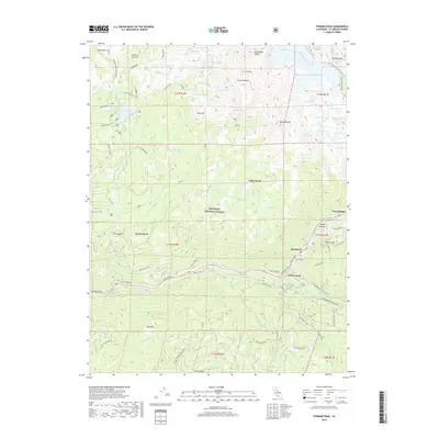
2018 Map of Pyramid Peak
USGS Topo · Published 2018About this map
Pyramid Peak and the Crystal Range dominate the high Sierra landscape of the Eldorado National Forest, where steep granite faces overlook a vast network of alpine water bodies. The northeastern corner is defined by Lake Aloha and the Pacific Crest National Scenic Trail, while the S Fork American River carves through the southern half of the map. Along the river corridor, the historic Pony Express route and El Dorado Fwy connect small mountain settlements such as Strawberry and Sciots Camp. The distribution of seasonal flats like Fourth of July Flat and Lower Forni reflects the region's heritage of high-country grazing and early pioneer travel. Traces of early transportation remain visible through established markers like the 39 Mile Stone and the 42 Mile Stone near Twin Bridges, providing a clear record of the historical highway's progression through this demanding terrain.
Find a feature on this map
85 named features on this map. Tap any name to fly to it.
Don’t see what you’re looking for? This feature index may not catch every label — zoom into the map to look around manually.
Map Details
Editions of this 2018 Pyramid Peak Map
This is the sole edition of this map. No revisions or reprints were ever made.
Other maps of this area

1889 · Pyramid Peak
USGS Topo · 1:125,000

1891 · Pyramid Peak
USGS Topo · 1:125,000

1895 · Pyramid Peak
USGS Topo · 1:125,000

1896 · Pyramid Peak
USGS Topo · 1:125,000

1947 · Sacramento
USGS Topo · 1:250,000

1948 · Sacramento
USGS Topo · 1:250,000

1951 · Leek Spring Hill
USGS Topo · 1:24,000
1951 · Leek Spring Hill
USGS Topo · 1:62,500
1952 · Kyburz
USGS Topo · 1:24,000
1952 · Loon Lake
USGS Topo · 1:24,000