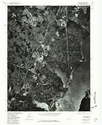
1977 Map of Quantico
USGS Topo · Published 1982About this map
Quantico and the surrounding Prince William County landscape are documented here via high-resolution orthophotography from the late 1970s. This aerial perspective, produced in cooperation with the Soil Conservation Service, reveals the suburban expansion and military infrastructure along the western bank of the Potomac River. The image captures the dense development of Woodbridge and the historic footprint of Dumfries, contrasted against the tidal inlets and wooded drainages of Quantico Creek and Neabsco Creek. By using rectified imagery instead of traditional line work, this sheet offers researchers a literal view of land use patterns, clearing for new neighborhoods, and the strategic positioning of the base at the confluence of the river and Chopawamsic Creek.
Find a feature on this map
7 named features on this map. Tap any name to fly to it.
Don’t see what you’re looking for? This feature index may not catch every label — zoom into the map to look around manually.
Map Details
Editions of this 1977 Quantico Map
This is the sole edition of this map. No revisions or reprints were ever made.
Other maps of this area

1889 · Fredericksburg
USGS Topo · 1:125,000

1890 · Mt. Vernon
USGS Topo · 1:125,000

1891 · Mt. Vernon
USGS Topo · 1:125,000

1892 · Fredericksburg
USGS Topo · 1:125,000

1894 · Fredericksburg
USGS Topo · 1:125,000

1894 · Mt. Vernon
USGS Topo · 1:125,000

1897 · Mt. Vernon
USGS Topo · 1:125,000

1913 · Indian Head
USGS Topo · 1:62,500

1913 · Nanjemoy
USGS Topo · 1:62,500

1923 · Indian Head
USGS Topo · 1:48,000