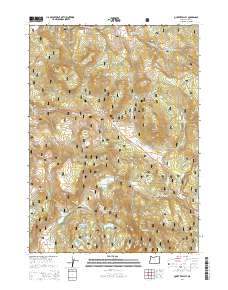
2014 Map of Quartz Valley
USGS Topo · Published 2014About this map
Fremont National Forest dominates this landscape in southern Oregon, where high-elevation terrain is defined by volcanic features and an extensive network of water management. The Klamath Falls-Lakeview Hwy crosses the center of the sheet, navigating the notable Quartz Mountain Pass near the peak of Quartz Mountain. This corridor serves as a vital transit point through the eastern Cascades, connecting the higher flats with the lower drainages.
Find a feature on this map
45 named features on this map. Tap any name to fly to it.
Don’t see what you’re looking for? This feature index may not catch every label — zoom into the map to look around manually.
Map Details
Editions of this 2014 Quartz Valley Map
This is the sole edition of this map. No revisions or reprints were ever made.
Other maps of this area

1955 · Klamath Falls
USGS Topo · 1:250,000

1958 · Klamath Falls
USGS Topo · 1:250,000

1960 · Strawberry Butte
USGS Topo · 1:62,500

1960 · Fishhole Mtn
USGS Topo · 1:62,500

1964 · Drews Reservoir
USGS Topo · 1:24,000

1964 · Coleman Point
USGS Topo · 1:24,000

1964 · Cougar Peak
USGS Topo · 1:24,000

1975 · Lakeview
USGS Topo · 1:100,000
1988 · Arkansas Flat
USGS Topo · 1:24,000
1988 · Barnes Valley
USGS Topo · 1:24,000