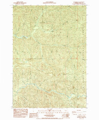
1985 Map of Quartzville
USGS Topo · Published 1985About this map
Quartzville remains the central focus of this mid-1980s landscape, marking the location of a former mining community within the Willamette National Forest. This survey captures a region shaped by extractive history and timber management, where the Albany Mine and numerous unnamed quarries dot the terrain near Edison Gulch and Packers Gulch. The road network is dominated by the Quartzville Road, which snakes alongside Quartzville Creek to provide access to the interior of the Cascades.
Find a feature on this map
40 named features on this map. Tap any name to fly to it.
Don’t see what you’re looking for? This feature index may not catch every label — zoom into the map to look around manually.
Map Details
Editions of this 1985 Quartzville Map
This is the sole edition of this map. No revisions or reprints were ever made.
Other maps of this area

1929 · Mill City
USGS Topo · 1:125,000

1934 · Mc Kenzie Bridge
USGS Topo · 1:96,000

1940 · Mc Kenzie Bridge
USGS Topo · 1:125,000

1953 · Salem
USGS Topo · 1:250,000

1954 · Salem
USGS Topo · 1:250,000

1955 · Cascadia
USGS Topo · 1:62,500

1955 · Echo Mountain
USGS Topo · 1:62,500

1956 · Quartzville
USGS Topo · 1:62,500

1956 · Detroit
USGS Topo · 1:62,500

1960 · Salem
USGS Topo · 1:250,000