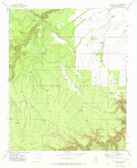
1971 Map of Quayle Hill
USGS Topo · Published 1973About this map
Coconino National Forest and Sitgreaves National Forest meet in this 1970s landscape defined by an extensive network of stock tanks and isolated landing strips. The terrain is deeply incised by drainages such as Chavez Draw and Jacks Canyon, which wind toward the prominent Quayle Hill in the northern reaches. The area's reliance on managed water for livestock and forest operations is evident in the dozens of named features like Twentytone Tank, McDermaid Tank, and Soldier Trail Tank. Aviation infrastructure serves this remote timber and grazing land through the Brown Landing Strip and Red Hill Landing Strip. Along the southern boundary, the map captures the steep descent into the canyons of Clear Creek and East Clear Creek, where a Gaging Station monitors the flow through the canyon floors near Leonard Point.
Find a feature on this map
45 named features on this map. Tap any name to fly to it.
Don’t see what you’re looking for? This feature index may not catch every label — zoom into the map to look around manually.
Map Details
Editions of this 1971 Quayle Hill Map
Other maps of this area

1886 · Holbrook
USGS Topo · 1:250,000

1887 · Verde
USGS Topo · 1:250,000

1892 · Verde
USGS Topo · 1:250,000

1893 · Holbrook
USGS Topo · 1:250,000

1954 · Holbrook
USGS Topo · 1:250,000

1955 · Sunset Knoll 2 SW
USGS Topo · 1:24,000

1955 · Sunset Pass
USGS Topo · 1:62,500

1957 · Holbrook
USGS Topo · 1:250,000

1958 · Holbrook
USGS Topo · 1:250,000

1960 · Holbrook
USGS Topo · 1:250,000