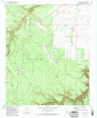
1971 Map of Quayle Hill
USGS Topo · Published 1986About this map
Quayle Hill rises above a high-desert landscape defined by complex water management and forest boundary lines in the late 1960s and early 1970s. The area is dominated by the Coconino National Forest, which meets the Sitgreaves National Forest at its southern edge along Clear Creek. The scarcity of natural surface water is evident in the dense network of man-made catchments, including the Soldier Trail Tank, McDermid Tank, and the descriptive Tank in the Road. For those tracking regional history, the map documents remote infrastructure like the Ranger Station and two localized airstrips, the AZ Landing Strip and Red Hill Landing Strip. Rugged drainages like Chavez Draw and Jacks Canyon cut through the terrain, while a Gaging Station on the southern creek indicates the importance of monitoring water flow in this arid environment.
Find a feature on this map
44 named features on this map. Tap any name to fly to it.
Don’t see what you’re looking for? This feature index may not catch every label — zoom into the map to look around manually.
Map Details
Editions of this 1971 Quayle Hill Map
Other maps of this area

1886 · Holbrook
USGS Topo · 1:250,000

1887 · Verde
USGS Topo · 1:250,000

1892 · Verde
USGS Topo · 1:250,000

1893 · Holbrook
USGS Topo · 1:250,000

1954 · Holbrook
USGS Topo · 1:250,000

1955 · Sunset Knoll 2 SW
USGS Topo · 1:24,000

1955 · Sunset Pass
USGS Topo · 1:62,500

1957 · Holbrook
USGS Topo · 1:250,000

1958 · Holbrook
USGS Topo · 1:250,000

1960 · Holbrook
USGS Topo · 1:250,000