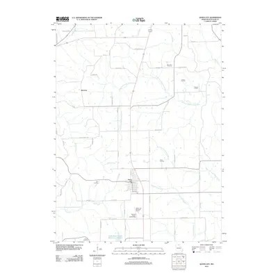
2012 Map of Queen City
USGS Topo · Published 2012About this map
Queen City and the surrounding Schuyler County countryside are defined by a complex network of waterways, including the South Fork Middle Fabius River, North Fork Salt River, and Sand Creek. This 2012 survey illustrates the rural character of the region, where a concentration of historical burial grounds such as Mount Zion Cemetery, Barnes Cemetery, and Thomas Cemetery provides valuable data for genealogists tracing early families. To the west, the small settlement of Julesburg sits along Elm Creek, while modern aviation infrastructure is represented by the Queen City Municipal Airport and the nearby Schuyler County Landing Strip. The landscape is largely agricultural, evidenced by a dense grid of local roads like Prairie School Rd and Hayshed Rd, punctuated by water resources like the Public Water Supply District 1 L Reservoir at the southern edge.
Find a feature on this map
53 named features on this map. Tap any name to fly to it.
Don’t see what you’re looking for? This feature index may not catch every label — zoom into the map to look around manually.
Map Details
Editions of this 2012 Queen City Map
This is the sole edition of this map. No revisions or reprints were ever made.
Other maps of this area

1903 · Edina
USGS Topo · 1:125,000

1911 · Queen City
USGS Topo · 1:62,500

1913 · Queen City
USGS Topo · 1:62,500

1954 · Centerville
USGS Topo · 1:250,000

1957 · Centerville
USGS Topo · 1:250,000

1958 · Centerville
USGS Topo · 1:250,000

1965 · Downing NW
USGS Topo · 1:24,000
1966 · Willmathsville
USGS Topo · 1:24,000
1974 · Queen City NE
USGS Topo · 1:24,000
1974 · Queen City NW
USGS Topo · 1:24,000