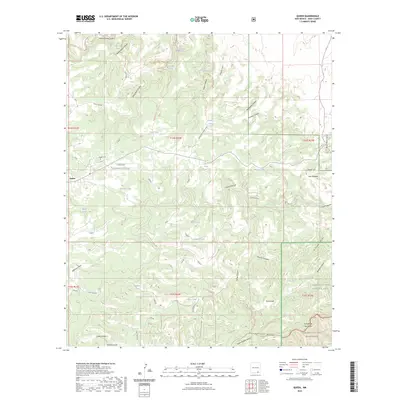
2023 Map of Queen
USGS Topo · Published 2023About this map
The settlement of Queen anchors this high-elevation landscape in the southern Guadalupe Mountains, where the modern boundaries of Lincoln National Forest meet the western reaches of Carlsbad Caverns National Park. This 2023 survey documents a terrain defined by deep incisions like Dark Canyon and Last Chance Canyon, and the crucial water sources that supported ranching and travel in this arid environment, including Sitting Bull Spring and White Oaks Spring. For those tracing local genealogy or land use, the Queen Cem and the complex network of tanks like Priestly Tank and Reed Tank illustrate the localized infrastructure of the high desert. Significant natural features such as Sitting Bull Falls and the Carlsbad Caverns Wilderness underscore the area's transition from forest management to protected karst landscapes.
Find a feature on this map
65 named features on this map. Tap any name to fly to it.
Don’t see what you’re looking for? This feature index may not catch every label — zoom into the map to look around manually.
Map Details
Editions of this 2023 Queen Map
This is the sole edition of this map. No revisions or reprints were ever made.
Other maps of this area

1935 · El Paso Gap
USGS Topo · 1:62,500

1936 · El Paso Gap
USGS Topo · 1:48,000

1940 · El Paso Gap
USGS Topo · 1:62,500

1940 · Bandanna Point
USGS Topo · 1:62,500

1940 · Carlsbad Caverns West
USGS Topo · 1:62,500

1943 · Carlsbad Caverns West
USGS Topo · 1:62,500

1943 · Bandanna Point
USGS Topo · 1:62,500

1943 · Texas Hill
USGS Topo · 1:62,500

1945 · Texas Hill
USGS Topo · 1:62,500

1954 · Carlsbad
USGS Topo · 1:250,000